This page aims to provide you with resources for studying the development of Harpenden over time.
To get an overview of Harpenden’s development consult these pages of this website:
http://www.harpenden-history.org.uk/page/an_introduction_to_harpenden
http://www.harpenden-history.org.uk/page/harpenden_the_growth_of_a_village_1
http://www.harpenden-history.org.uk/page/harpenden_the_growth_of_a_village_2
http://www.harpenden-history.org.uk/page/harpenden_the_growth_of_a_village_3
Below are sources you could use with the students to allow them to investigate how Harpenden has changed. Links to sources on external sites are in the body of the text, and all the other documents are at the end of the text under ‘downloads’.
SAXON / EARLY NORMAN
The deed of 1060 is the first written mention of “Herpedene”. It is included to describe the area contained within the Parish of Wheathampstead (which Harpenden was part of until 1859), rather than as a place in its own right. The Charter records Edward the Confessor granting the parish to Westminster Abbey. Two images are included at the bottom of this page, which can be printed placed side to side to create an A3 version of the document. You can read the translation of this document here: http://www.harpenden-history.org.uk/page_id__271.aspx
The Domesday book can be viewed online here: http://opendomesday.org
It was a survey of all the land in England in 1085, carried out by the order of William the Conqueror the first Norman king of England. Harpenden is not mentioned here, but you can read the entry for the parish of Wheathampstead (Watamstede), which we know from the above deed included Harpenden. This reveals that there were just 37 households in the whole parish, and lists 4 mills as well as other farming resources. Make sure you show students the original page as well the translation of the information that it contains. Also bear in mind that although this was produced after the Norman conquest, the settlement and farming practices it describes give us a picture of life here in Saxon times as there is no reason to think major changes took place in parish life in the first twenty years of Norman rule.
18TH AND 19TH CENTURY MAPS
The Dury and Andrews map was printed in 1766. There are 2 photographs of the copy in the Hertfordshire archives at the end of this page, or you can see it online here:
http://www.duryandrewsmapofhertfordshire.co.uk/explore-the-map.php?tile=15#tof
The Bryant map was printed in 1822. There is a photograph of the copy in the Hertfordshire archives at the end of this page.
VICTORIAN RECORDS
Photographs
You can find photographs from late Victorian times here on the website, the most useful section is the picture gallery: http://www.harpenden-history.org.uk/category_id__76.aspx
Maps
The first entire series of ordnance survey maps of England and Wales was produced in 1870. These are an invaluable resource with their detailed and accurate mapping of the area. These and later maps can be viewed for free here:
To get maps of Harpenden:
- Find by place
- Enter Harpenden
- Select Great Britain, Ordnance Survey / OS Six-inch, 1842-1952
Census records
These can be accessed online for free in local libraries at these websites:
Although you need to pay if you want to access these outside of the library, both sites offer free trials. You can see photographs of the original forms filled in by census enumerators as well as modern transcripts.
School records
School logs and admission registers are also available on www.findmypast.co.uk
Baptisms, burials, marriages
These can also be accessed on www.findmypast.co.uk, and the records go back beyond Victorian times, with baptisms starting in 1610 and burials in 1653. These are searchable by name so you could find records about an individual you had come across in a census.
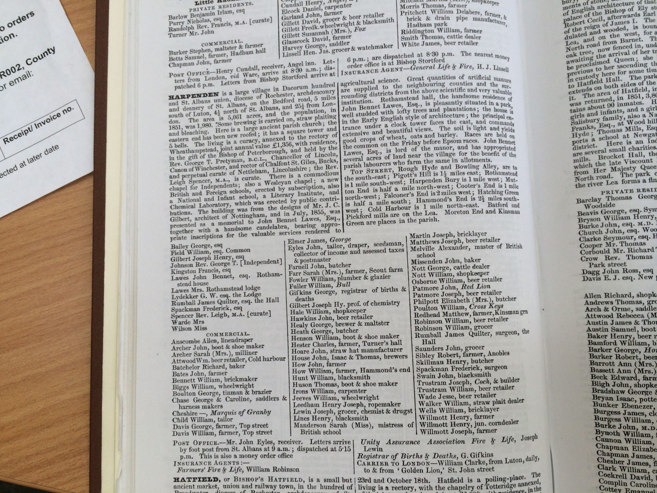
Trade directories
These were lists of different businesses in cities, towns or villages, but also contained brief descriptions of the area, local institutions and the wealthier private residents.
Below under ‘downloads’ you will find photographs of the Harpenden section of Kelly’s directory or the Post Office directory for these years:
1851
1859
1869
1882
1890
1900
There is also the section on straw plaiting from 1869.
TWENTIETH CENTURY
Maps
The ordnance survey maps available online for free at http://maps.nls.uk/os/ provide a clear illustration of the growth of Harpenden in the first half of the twentieth century, with maps revised in 1922, 1938 and 1946.
Trade directories
These are also available for the twentieth century. Harpenden Public Library has copies of Kelly’s Directories that you could consult. We intend to put images of these up on these pages in the future.
Harpenden development plan, 1951
In 1951 Hertfordshire County Council published a general development plan for the county, and also plans for the individual towns including Harpenden. This provides a wealth of information about Harpenden in 1951 as well as projections and plans for the future. There are selected pages below in the downloads section: the map showing proposed areas of development, 1951-1973, as well as pages on shops, employment and schools. The full development plan can be found in Harpenden library in the local studies section (711.4HAR)

No Comments
Add a comment about this page