1. This OS map of 1890 shows the contours marking the head of the valley at Zouches Farm in the top left-hand corner
Photo of map, RR
2. Geological map of UK, showing clay overlay between Rothamsted and Slip End
R.Ross, January 2015
3. View from the top of the valley, looking east towards Zouches Farm, with Grove Spring to the south. Behind the photographer lies the edge of the escarpment of Blows Down, above Dunstable.
R Ross, April 2014
4. Looking west to the top of the valley from the corner of Zouches Farm yard on the right; Grove Spring on the left
R Ross, Jan 2015
5. The gentle slope eastwards towards Zouches Farm - in the centre of the photo.
R Ross, April 2014
6. Zouches Farm from the west, nestling in the valley which passes through the farm-buildings.
R Ross, April 2014
7. The pool at the eastern end of Grove Spring, supplying the farm, which lies behind the photographer
R Ross, Jan 2015
8. Zouches Farm from the south, with Grove Spring on the left. The valley passes 'horizonally' behind the farm.
R Ross, April 2014
9. The farm sheltered in the valley, running eastwards.
R Ross, April 2014
10. Looking NE. The valley continues eastwards to Caddington Golf course, where it feeds several ponds. We have not been able to visit this section yet.
R Ross, April 2014
11. Caddington Golf Course - looking WNW, with Zouches Farm behind the copse on the left
Rosemary Ross, 1 November 2015
12. Caddington Golf Club, looking ESE towards Club entrance
Rosemary Ross, 22 November 20
13. Looking east from the field just south of Caddington Golf Course; the lakes lie the valley behind the hedge on the left of the photo. Badgerdell Wood and Farley Green are on the horizon.
Rosemary Ross, 22 November 2015
14. Chaul End Road, entrance to Caddington Golf Club - looking South - the valley crosses the road, through the hedgerow, towards Badgerdell Wood.
R Ross, October 2015
15. Chaul End Road, entrance to Caddington Golf Club - looking North
R Ross, October 2015
16. North of Caddington, looking NW alongside Badgerdell Wood, towards Chaul End Road and Caddington Golf Club
Rosemary Ross, 1 November 2015
17. The dip alongside Badgerdell Wood, looking NW to Chaul End Lane
R Ross, October 2015
18. Badgerdell Wood on the left - looking SE towards Farley Green
R Ross, October 2015
19. The 'valley' runs SE alongside the hedgerow, and through the gap to Farley Green
R Ross, October 2015
20. View across to Farley Green - the 'valley' runs along the further hedgerow
R Ross, October 2015
21. Line of ditch along Old Farley Lane, private and inaccessible. M1 in background; underpass to the right.
Rosemary Ross, March 2014
22. Ditch with rivulet feeding pond at Farley Green
Rosemary Ross, March 2014
23. Ditch alongside Farley Lane Cottages, which feeds through a culvert into the pond at Farley Green
Rosemary Ross, March 2014
24. Sketch map of the dry valley from Farley Green to Kinsbourne Green
LHS archives - L Casey, 1980s
25. The Pond at Farley Green, fed from rivulet which passes under the M1
Rosemary Ross, November 2014
26. Southern end of pond at Farley Green: road past Stockwood Park Golf Course to Newlands on the left
Rosemary Ross, March 2014
27. View SE from pond at Farley Green, along Stockwood Park boundary
Rosemary Ross, March 2014
28. Newlands Road, alongside the boundary of Stockwood Park, near Farley Green
Rosemary Ross, March 2014
29. Newlands Road, looking north towards Farley Green, with Stockwood Park Golf course to the east and the watercourse on the left
LHS archives - L Casey, Jan 2015
30. Newlands Road, near the turning for Slip End, looking north - Grid Ref.095189
LHS archives, L Casey, Jan 2015
31. Road to Slip End from Newlands Road, rises up the side of the valley, under the M1
LHS archives, L Casey, Jan 2015
32. Newlands Road, with Newlands Farm, towards underpass of MI, Junction 10 spur
LHS archives, L Casey, Jan 2015
33. View of Newlands Road and Farm from A1081 which climbed to meet M1 spur & Luton Airport Parkway, since modified for new junction layout in late 2015
LHS archives - L Casey, Jan 2015
34. A substantial drainage ditch alongside the A1081, near to Gibraltar Farm - looking SE
LHS archives - L Casey, Jan 2015
35. Bedfordshire-Hertfordshire border, looking NW - north of Thrales End Lane
36. Bedfordshire-Hertfordshire border, looking SE, from Kennel Lane junction
LHS archives - L Casey, 1980s
37. Shire Mere or boundary - the junction at Thrales End Lane of two Roman trackways, one from Granary Lane/Ambrose Lane and the other through Caddington to Dunstable, with the track from St Albans (Verulamium) and Luton - the 'Herpedene'
LHS archives - L Casey, Jan 2015
38. Luton Road, near the Fox - the valley bottom heads towards Kinsbourne Green
LHS archives - L Casey, Jan 2015
39. Here we take a diversion to visit the tributory 'River Kin', rising near White Walls, north of Spring Road, Kinsbourne Green
LHS archives - L Casey, Jan 2015
40. 'River Kin' - newly dug lake, east of Whitewalls, north of Spring Lane, with Kennel Lane at the far boundary
LHS archives - L Casey, Jan 2015
41. The new lake, north of Spring Road, Kinsbourne Green
LHS archives - L Casey, Jan 2015
42. Kennel Lane floods frequently at a dip, east of the new lake
LHS archives, L Casey, Jan 2015
44. 'River Kin' - dip in Kennel Lane, and across the field - seen from A1081
LHS archives - L Casey, Jan 2015
45. Drainage ditch alongside The Common, Kinsbourne Green
LHS archives - L Casey, Jan 2015
46. Ditch alongside Luton Road, remnant of old watercourse
LHS archives - L Casey, Jan 2015
47. Ditch in old gravel pit, alongside Luton Road
LHS archives - L Casey, Jan 2015
48. Southern end of gravel pit alongside Luton Road, near Ridgewood Drive
LHS archives - L Casey, Jan 2015
49. Gravel workings near The Old Bell, Luton Road, from 1898 OS map
R Ross from map
50. A factory was built in the old gravel pit at the bottom of Roundwood Lane - site of Homedell since 1980s
LHS archives - L Casey c.1970
51. Sketch map of the dry valley from Kinsbourne Green to Grove Road
LHS archives - L Casey, 1980s
52. The Cock Pond in 1897.
LHS archives - LHS 011772
53. The culverted stream in winter, near the Cock Pond. Note the rustic bridges.
LHS archives - scan of HC 023
54. Lower High Street, near Vaughan Road, with rustic bridge over the stream - and a flood in c.1910
LHS archives - LHS 006437
55. The stream continued past the Harpenden Arms Hotel
Scan from 'Bygone Harpenden'
56. The Dell - the water-filled gravel pits on the Common - c.1900
LHS archives - LHS 001418
57. The Dell in the early 1900s. Old gravel pits had been dug out, as unemployment relief in 1895.
LHS archives - LHS 014683
58. In 1928 work started on draining the Cock Pond and culverting the stream all the way to the 'run-off' ponds on the Common
LHS archives - scan of B 2.61
59. Excavations for the construction of the 'run-off' ponds - 1928
LHS archives - LHS 001834
60. Concrete barriers were built around the Cock Pond, as road traffic increased, but did not solve the problems. Heavy storms overwhelmed the new culvert in 1936 and 1937
LHS archives - EB High Street North album
61. Maybe this, and the previous picture, were taken during the storm of 21 June 1936 - see the description of this great storm.
LHS archives - EB High Street North album
62. Clearing up in Lower High Street, after a storm on 13 August 1937
LHS archives - LHS 002893
63. Southdown Road (formerly Wheathampstead Road), behind the Harpenden Arms. Storm waters still (usually) flow through here to the old gravel pits on the Common.
L Casey
64. The valley bottom continues alongside Southdown Road, past The Dene, through a culvert into the ditch which drains into the first pond. 'Dene' derives from a Saxon word for valley.
LHS archives - L Casey
65. The drainage channel emerging from the outflow pipe from Harpenden Lower High Street
LHS archives - L Casey
66. Looking NW along the drainage ditch
LHS archives - L Casey
67. The channel flows into the first pond
L Casey
68. The first pond, looking south
L Casey
69. Path from the Common to Southdown Road at north end of first pond - dipping down to the floor of the valley
LHS archives - L Casey
70. The second pond, viewed from the Common towards Southdown Road and pines planted by Mr H Tylston Hodgson
LHS archives - L Casey
71. The soak-away 'third pond', viewed from the second pond. Water soaks away into the chalk substratum.
LHS archives - L Casey
72. However, in February 2001 John Davis captured a moment when the soak-away filled to become the third pond
LHS archives - LHS 012552 - John Davis
73. Since the restoration work in 2010, overflows are rare - this is a haunt for rabbits.
LHS archives - L Casey
74. The valley continues along the Southdown Road, under the Skew Bridge and through to Southdown Green. Piggotshill Lane and Cravells Road reach the bottom of the valley at the junction with Grove Road
LHS archives - L Casey
75. On 21 June 1936, storm waters from the sides of the valley caused deep flooding in Grove Road - here at the corner with Piggottshill Lane
LHS archives - LHS 000967
76. To alleviate the risk of flooding, Harpenden Urban District Council excavated and deepened an old gravel pit at the end of Dark Lane to form a deep sump
LHS archives - LHS 012139
77. The deep pool is still there behind the wall in Grove Road. During WWII a hatch was cut through the roadside wall, with a door labelled 'E.W.S.': this was an emergency water supply for the Auxilliary Fire Brigade. The hole was still there in 1962.
LHS archives - LHS 012139
78. The valley bottom, viewed from the Broadstone estate when under construction in the 1970s. View across to the Grove estate.
LHS archives - LHS 001882, LFC
79. These flats at the eastern end of Grove Road were built in the 1970s on the site of another gravel pit.
LHS archives - LHS 001357 LFC
80. Sketch map of the dry valley from Harpenden to Sandridge
Les Casey
81. From the end of Grove Road in the distance, to the junction with Pipers Lane on the right.
R Ross, October 2015
82. The track from Pipers Lane to Westend farm, looking WNW towards Cross Farm and Grove Road
R Ross, October 2015
83. The track looking towards Westend Farm.
R Ross, October 2015
84. A straight track leads all the way to Waterend Farm
R Ross, October 2015
85. West End Farm, Ferrers Lane
LHS archives - L Casey, Aug 2014
86. Gravel pits in the long depression opposite West End Farm
LHS archives - L Casey, Aug 2014
87. Gravel pits in Nomanland Common alongside Ferrars Lane
LHS archives - L Casey, Aug 2014
88. Nomansland Common: depression running alongside Ferrers Lane
LHS archives - L Casey, Aug 2014
89. Ferrers Lane from S Harpenden to crossroads with B 651- looking NW - Grid ref. 175123
LHS archives - L Casey, Aug 2014
90. Drovers Lane continues across the B 651 from Ferrars Lane, and bends towards Sandridge, grid ref 175123
LHS archives - LFC Aug 2014, LH 14154
91. At the Nomansland crossroad, a gap in hedge reveals a depression in valley floor.
LHS archives - L Casey, Aug 2014 LH 141155
92. Gravel pits alongside Drovers Lane, Nomansland Common - Grid ref. 175123
LHS archives - L Casey, Aug 2014 LH 141157
93. Depression and gravel of ancient river bed, on Nomansland Common alongside Drovers Lane.
LHS archives - L Casey, Aug 2014, LH 141156
94. Normansland - North of Drovers Lane - where ancient river deposited gravel
LHS archives - L Casey LH 14158
95. Exposed gravel on Nomansland Common.
LHS archives - L Casey, Aug 2014, LH 14159
96. Entrance to Nomansland Farm, to the North-East of Drovers Lane.
L F Casey, 2014
97. A gently sloping drive leads up to Nomansland Farm at Grid ref. 172127
L F Casey, 2014
98. Drovers Lane joins Coleman Green Lane, which leads SW towards Sandridge, at Grid ref. 179116
L F Casey, 2014
99. Coleman Green Lane: after the junction with Hammonds Lane, it swings towards Sandridge
L F Casey, 2014
100. On the South-East side of Coleman Green Lane the land rises to woodland south of Hammonds End Farm at Grid ref. 177114
L F Casey, 2014
101. At the north end of Sandridge, Coleman Green Lane (on the right) joins The Hill. It has skirted round the higher ground followed by the main road from Wheathampstead (B 651) at Grid ref. 172110
L F Casey, 2014
Sketch map of the dry valley from Jersey Farm to the Colne basin at Smallford
Les Casey
102. Looking north up the B651, as it joins the valley at Sandridge
L F Casey, 2014
103. Langley Grove climbs gently to the east, from Sandridge High Street at Grid ref. 171107
L F Casey, 2014
104. House Lane follows the valley ESE from Sandridge High Street
L F Casey, 2014
105. Looking east along the hedgerow beside House Lane, the valley curves SE by the hedge in the distance, towards Jersey Farm.
R Ross, January 2016
106. Looking NNE at the junction where House Lane meets Sandringham Crescent, on the eastern side of the Jersey Farm estate
R Ross, January 2016
107. From the junction with Sandringham Crescent, House Lane continues S-SSE on the edge of the Jersey Farm estate
R Ross, January 2016
108. House Lane meets Sandpit Lane and Oaklands Lane at a T-junction. The valley turns eastwards along Oaklands Lane towards Smallford.
R Ross, January 2016
109. From Oaklands Lane at Grid ref. 191079 a belt of trees runs down to Hatfield Road, alongside the nurseries at Smallford.
L F Casey, 2014
110. An old neglected watercourse follows the belt of trees - Grid ref. 191079.
L F Casey, 2014
111. The old watercourse alongside the nurseries at Smallford comes to and passes under the old railway track, now Alban Way at Grid ref. 195071
L F Casey, 2014
112. Alban Way near Smallford station platform
Les Casey, 2014
113. At Grid ref. 196072 the drainage channel along the west side of Smallford nurseries passes under the railway/Alban Way and continues towards the River Colne.
L F Casey, 2014
114. Drainage channel alongside Smallford nurseries near the bridge under the Alban Way.
L F Casey, 2014
115. One channel of the Colne passes under Colney Heath Lane, NW of the junction with the North Orbital Road at Grid ref. 198063
L F Casey, 2014
116. Alongside the cycleway at Grid ref. 197071, one of the lakes in the Colne valley is now used for fishing
L F Casey, 2014
Sketch map of the dry valley, showing its relationship to the Lea and Colne valleys
Les Casey
Bruce Campbell’s proposition that there was once a river Kin, prompted us to trace the shallow dry valley which runs through Harpenden from its source on the dip-slope below Blows Down near Dunstable to Smallford in the basin of the river Colne.
Rivers of the Chilterns
During the Ice Age, the rocks and soils of the Chiltern Hills were frozen into impermeable ‘permafrost’.
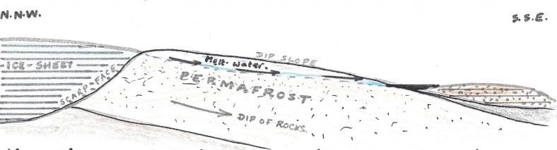
When the ice-sheet began to melt, water poured over the still-frozen ground of the dip-slopes, cutting the deep valleys of the Lea, Ver, Gade etc. Where the lobe of glacial boulder clay still blocked the the way, terraces of glacial ‘outwash’ gravel were formed along the Lea valley. Eventually the Lea overflowed and cuts its eastward course, reaaching the Thames to the east of London. The Ver and Gade joined the Colne, which flowed south-west, reaching the Thames to the west of London.
Many tributary valleys, such as the valley through the centre of Harpenden, formed later and were shallower, so when, at the end of the period of glaciation the underlying chalk became permeable again, the water-table fell below the level of these valley floors, and they became ‘dry valleys’. Some have streams which re-appear in wet years. The valley through Harpenden and Sandridge is a ‘dry valley’.
Surface Drainage
Most of the rainfall on this district soaks through the soil and the permeable chalk rock beneath to add to the water-table of the aquifer.
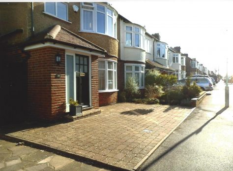
Paving front gardens for parking cars adds to the problems of surface drainage. Credit: Les Casey
But during heavy rainfall there is also some surface drainage down the slopes of the valley sides. Water will flow in ditches off the patches of clay drift deposits on the chalk ridges. Storm-water runs off tarmac road surfaces and paved areas in the town, finding its way into the roadside ditch and so into the town drainage system which carries this run-off water to the Southdown storage ponds, whence it overflows into the soak-away pit to percolate into the chalk below.
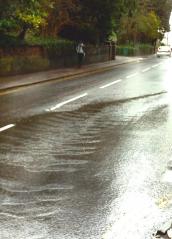
Water streaming down Station Road on 26 February 2015. Credit: Les Casey
The gravel-pit at the foot of Dark Lane similarly serves as a sump for the run-off from roads at Southdown.
There are other pits in the valley-gravel at intervals along the valley floor through No Mans Land and Sandridge, down to the Colne.
The dry valley in pictures
The long gallery below follows the valley, as far as it can be accessed. The northern section mainly runs through private land, and can only be viewed from footpaths which give views along the line of the shallow dip which is the valley. The sequence has been put together over several years, in varying weather, and includes some old photos at times of flood or when there was more visible water in the centre of Harpenden.
To view the pictures, click on the first picture (or wherever you want to start your exploration) to enlarge the image. Then press next, or previous, to progress on your virtual walk.
Author
By Les Casey and Rosemary RossPage last edited
19/07/2021Page created
08/03/2015Page created by
Rosemary Ross


 and Luton - the 'Herpedene'")


, behind the Harpenden Arms. Storm waters still (usually) flow through here to the old gravel pits on the Common.")


 joins The Hill. It has skirted round the higher ground followed by the main road from Wheathampstead (B 651) at Grid ref. 172110")


No Comments
Add a comment about this page